


Precision Ag Update - August 2026
Can high resolution UAV-derived weed maps replace camera based targeted spray application?
Written by: Madhusudhan Adhikari and Ricardo Pinto, August 2026
Summary
Managing weeds precisely across no-till dryland fields is critical to keeping your herbicide costs down, but the high investment on tractor-mounted camera systems leaves many producers looking for a more affordable alternative. Flying drones to map weeds and generate prescription maps for your spray drone or ground rig as a low-cost solution is becoming more popular in Montana. To see if this approach delivers the accuracy you can rely on, our team compared drone-based weed detection methods using vegetation indexes and computer vision models against a standard ground-based camera system.
Methods
We tested this approach across three application dates in 2025 (April 24, May 22, and June 24) on a summer fallow field at the Northern Ag Research Center (NARC). Using a Kubota UTV mounted with a Carbon Bee SmartStriker X camera-sprayer system (Figure 1), we made three separate herbicide applications following standard local practices. Right before each pass, we flew a drone at 65 feet to capture standard color (RGB) and multispectral imagery. To see how well drone mapping holds up against the ground-based camera system, we compared three different drone methods:
- Standard Color (ExG): Using basic color differences between the crop ground and weeds.
- Near-Infrared (NIR): Using multispectral band thresholds.
- AI Model (YOLO): Training a deep learning computer vision model to spot weeds in the drone photos.
We measured how accurately each drone method counted weeds compared to the camera-based system by tracking how many weeds the drones missed, checking error rates, and running standard statistical comparisons to see which mapping approach came closest to the ground truth.
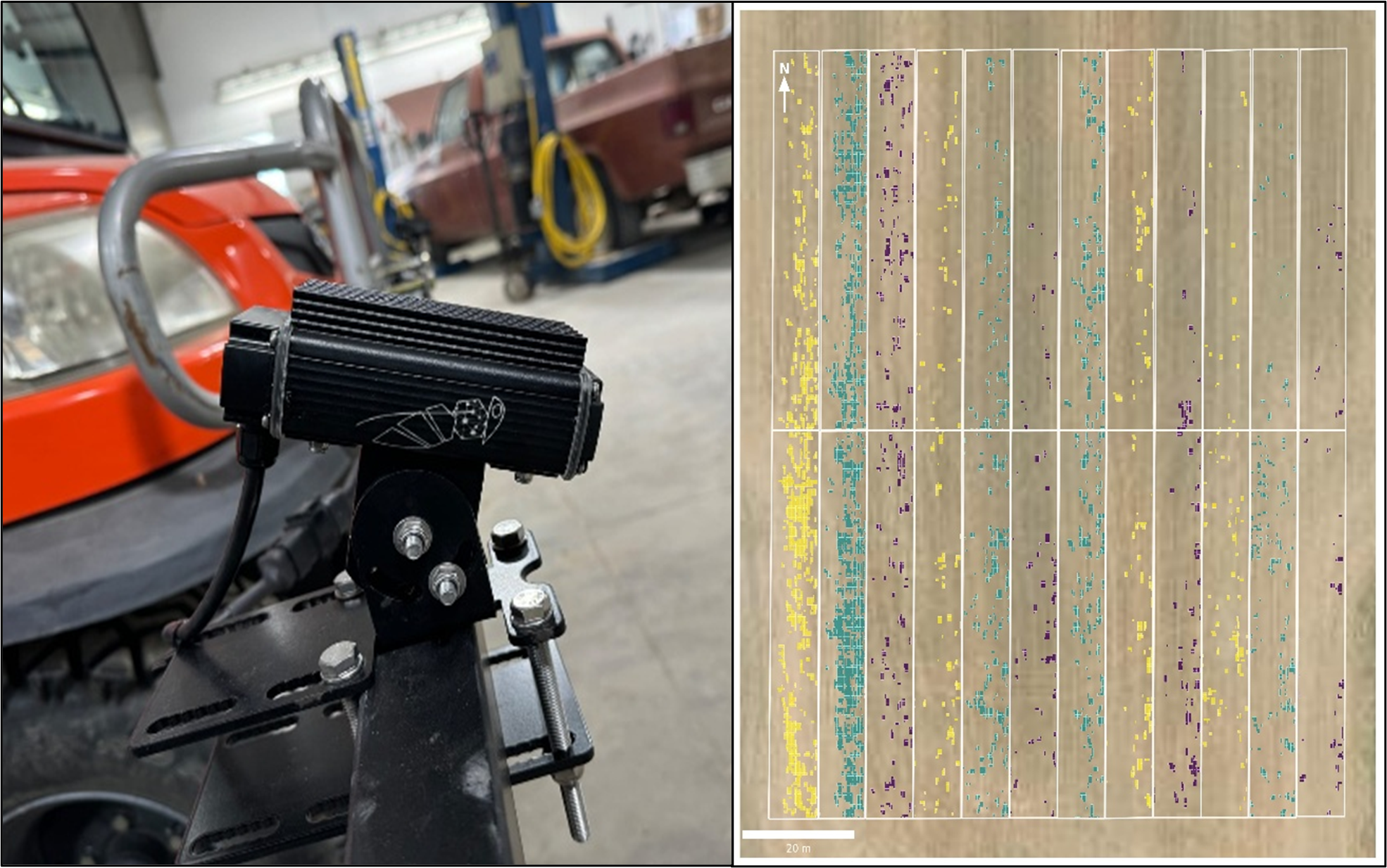
Figure 1. Carbon Bee SmartStriker X sensor equipped with integrated RGB (Red, Green, Blue) and hyperspectral cameras for real-time weed detection and mapping mounted on Kubota-UTV (left) and as-applied maps showing weed detected area in different colors for different treatments (right) during the study.
What we observed
Across all flight dates, standard color imagery (RGB) was the most accurate and consistent drone-based method for estimating weed counts (Figure 2).
Here is how the three drone methods performed:
- Standard Color (RGB): Matched up most closely with the ground-based camera system.
- AI Deep Learning (YOLO): Excellent at mapping where the weed patches were located across the field, but it severely undercounted the actual number of weeds.
- Near-Infrared (NIR): Showed inconsistent results because the sensors were overly sensitive to changing sunlight, soil moisture, and crop residue.
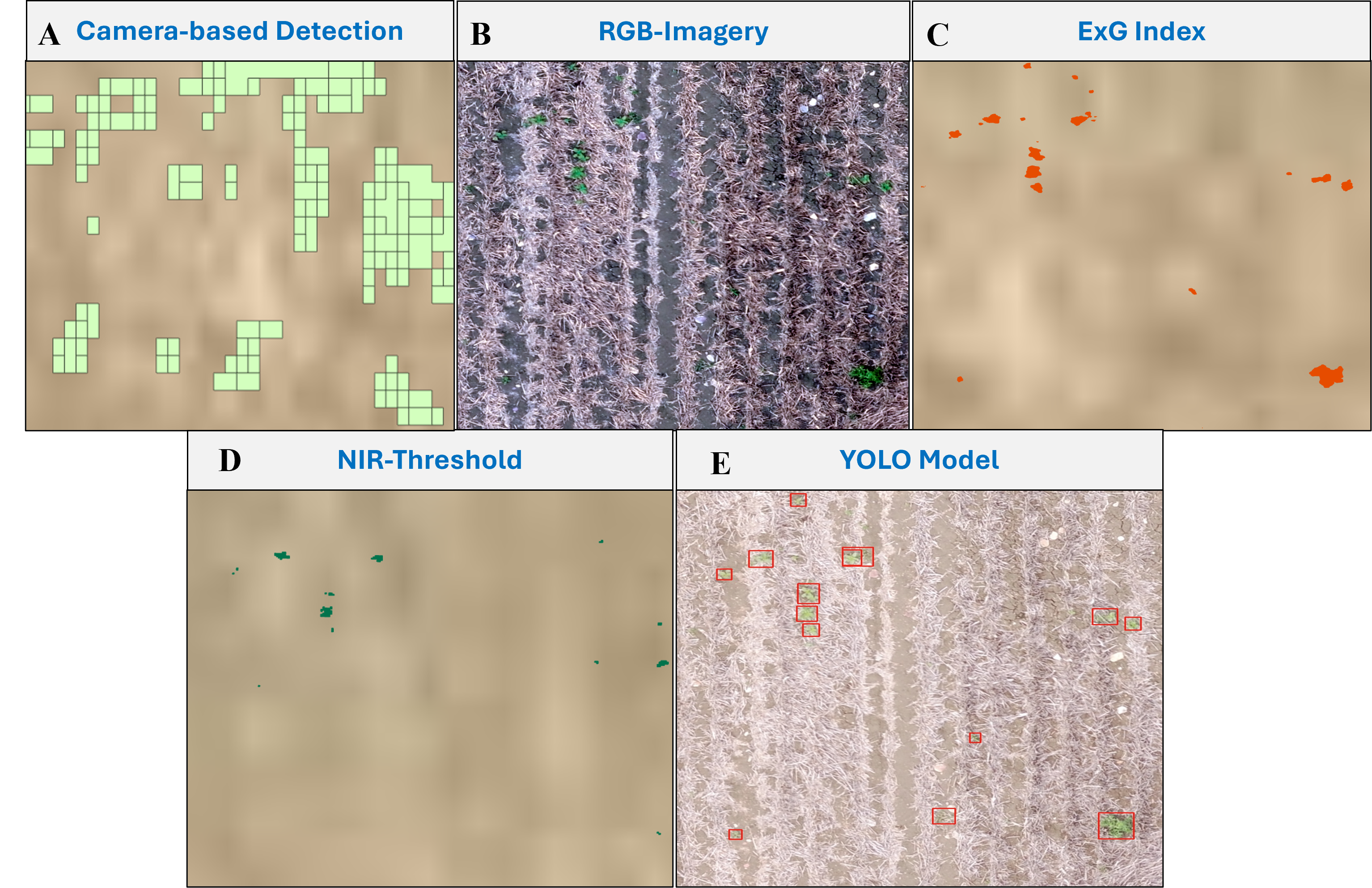
Figure 2. Illustration of weed detection outputs for a representative field section from June 24, 2025, imagery collection.
Key Takeaways
Plot-level weed counts from the sprayer-mounted camera were consistently higher than all drone methods across every flight date. The reason comes down to ground perspective: the sprayer camera can spot tiny weeds (about the size of a coin up to a golf ball) hiding down in the crop residue that aerial drones simply miss from 65 feet up.
- Weed Omission Rates: Standard color (RGB) missed between 41% and 65% of weeds, NIR missed 48% to 74%, and the AI model missed 78% to 85% compared to the ground camera (Figure 3).
- Seasonal Timing: Drone accuracy was acceptable early in the season (April). By May and June, accuracy dropped because larger, taller weeds began blocking the drone's view of smaller weeds growing underneath them.
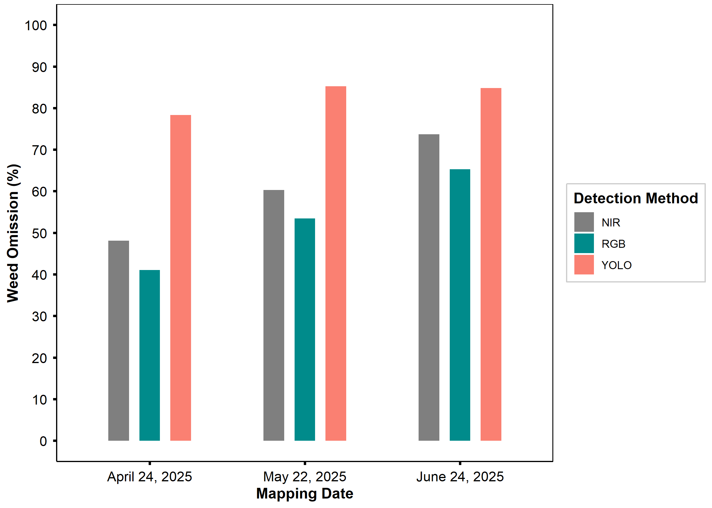
Figure 3. Weed count omission (%) for different prediction methods compared to Camera-based at different weed mapping dates during the 2025 study year.
What This Means for Your Operation
While drone mapping is a lower-cost option for creating prescription maps, sprayer-mounted camera systems remain the gold standard for real-time, high-accuracy weed detection. This is especially true on large farms (~2,400 acres), where managing battery life, multiple drone flights, and lengthy processing times can become a bottleneck during tight application windows.
Drone mapping can still be a helpful tool for spotting major weed patches, but producers should be aware that aerial prescriptions will underapply to small weeds tucked under stubble or hidden beneath larger canopies.
Acknowledgements
We are grateful to the Montana Agricultural Experiment Station and the Montana Wheat and Barley Committee for funding this research.
References
Full link to Journal Article: https://doi.org/10.3389/fagro.2026.1817915
Get Connected & Learn More

Dr. Ricardo Pinto
Assistant Professor, Precision Agriculture Research and Extension Specialist

Madhusudhan Adhikari
Research Assistant
madhusudhan.adhikari@montana.edu