


Precision Ag Update - September 2026
Field-Scale Wheat Stem Sawfly Detection Using Satellite Radar and Machine Learning
Written by: Sudhir Payare and Ricardo Pinto, September 2026
Summary
The wheat stem sawfly (WSS) is one of the most devastating insect pests facing wheat producers in Montana. Current management of WSS primarily relies on planting solid-stem wheat cultivars and rotational crops that are either non-hosts or poor hosts for WSS, as insecticide use is largely ineffective or cost-prohibitive. Characterizing WSS infestations can help producers make informed decisions about adopting solid-stem cultivars, planting rotational crops, or swathing specific wheat fields. However, the only reliable way to assess infestation is to manually cut and dissect stems, which are impractical across the large fields typical of Montana and are usually done after harvest, when it is too late to act.
Our team at Montana State University's Northern Agricultural Research Center (NARC) in Havre, along with entomologists and remote sensing specialists in Bozeman, are working to change that. Using freely available satellite data and machine learning, we developed a method to map sawfly infestation levels across entire fields approximately two weeks before harvest, early enough to make management decisions. By tracking how sawfly larvae weaken stems and alter canopy structure, we developed a computer model that predicted stem cutting damage with 80% accuracy across spring wheat fields in Hill and Chouteau counties during the 2025 season, roughly two weeks before harvest. By quantifying infestation patterns across large areas, growers can prioritize areas to seed WSS resistant cultivars or adopt crop rotation in areas of persistent infestation.
Methods
The study combined satellite radar, drone mapping, and hands-on field sampling. Traditional optical satellites (like Sentinel-2) take images based on light reflectance, which tells us how green or healthy a crop looks. However, greenness alone does not reveal whether a stem is hollowed out inside. Instead, we focused on combining optical satellites with satellite radar (Sentinel-1), which penetrates the upper leaves and physically interacts with crop structure. As sawflies chew through inner stem walls, plants lean, bend, or drop slightly, changing how radar signals bounce back to the satellite. To double-check these structural radar readings, a drone carrying a laser scanner (LiDAR) flew over fields 5 to 7 days before harvest to map fallen or leaning wheat. We then collected stem samples from ~200 locations across the fields and dissected stems to verify sawfly cutting. This field data was fed into a predictive computer model (machine learning) to test how accurately satellite radar could spot WSS damage before harvest without anyone having to cut stems by hand.
Field experiment was conducted during the 2025 growing season across two commercial dryland spring wheat fields planted with the cultivar Vida. Field 1 was located in Chouteau County and covered 318 acres, while Field 2 was in Hill County covering 158 acres.
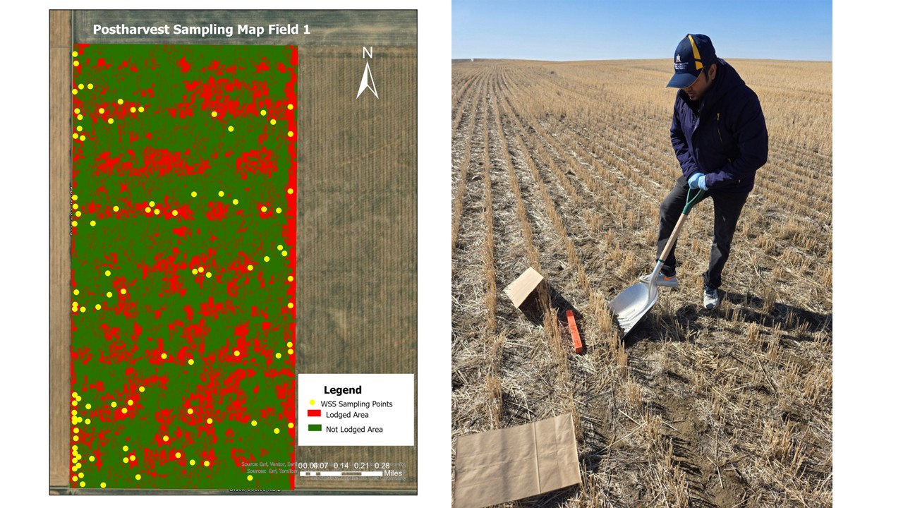
Figure 1. Post-harvest sampling map for Field 1 displaying drone-derived lodging boundaries (red = lodged wheat, green = unlodged wheat) paired with georeferenced stem dissection sampling locations (Left). Wheat stubble sample collection in the field post-harvest to verify wheat stem sawfly cutting and larvae infestation (Right).
What We Observed
- Radar Sees Plant Structure Changes: Traditional color reflectance alone often misses early sawfly damage, but when combined with satellite radar it picked up structural changes in the wheat canopy caused by stem weakening, showing clear differences between low-damage (<20% stem cut) and high-damage (>20% stem cut) areas up to two weeks before harvest.
- Low Spots Suffer Most: Field elevation maps were the strongest predictor of sawfly damage. This is an indication that low areas can hold more soil moisture, producing taller stems that female sawflies can target first for laying eggs.
- High Model Accuracy: The satellite prediction model hit the mark on test fields, matching manual field cut counts (Field 1: 22.8% modeled vs. 22.7% manual; Field 2: 0.5% modeled vs. 1.8% manual).
- Edge Effect Confirmed: Satellite maps clearly showed that sawfly damage concentrated heavily along field borders, a well-known behavior for this insect.
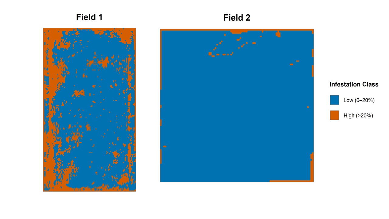
Figure 2. Field-scale machine learning prediction maps of pre-harvest wheat stem sawfly infestation. Satellite radar (Sentinel-1) and machine learning model predictions mapped across Field 1 (Chouteau County) and Field 2 (Hill County). Blue areas represent low infestation (≤ 20% stem cut) and orange areas represent high infestation (>20% stem cut), highlighting significant edge effects and localized hotspot aggregation.
Implications
- Having an infestation map two weeks before harvest allows growers to selectively swath heavily damaged field locations.
- Detailed maps highlight persistent sawfly hotspots year after year. Growers can use this data to plant solid-stem varieties only in high-risk zones where stem strength is vital, while keeping hollow-stem varieties in low-risk fields.
- We are currently working to turn this system into a free, easy-to-use digital map tool. The goal is to deliver live sawfly risk maps directly to Montana producers.
Acknowledgment
The authors thank the Montana Agricultural Experiment Station for providing funding for this study. We also thank the Montana State University Geospatial Core Facility for support with LiDAR data acquisition and processing. We are grateful to producers for allowing data collection on their fields. Finally, we thank Jena Sanders for helping process the wheat samples.
Get Connected & Learn More

Dr. Ricardo Pinto
Assistant Professor, Precision Agriculture Research and Extension Specialist